Here are beautiful pictures of the Region of Stoborough . Isle of Purbeck in Dorsetshire. Escape the crowds and head to one of the most serene and beautiful regions of Southern England which was Ancient Wessex.
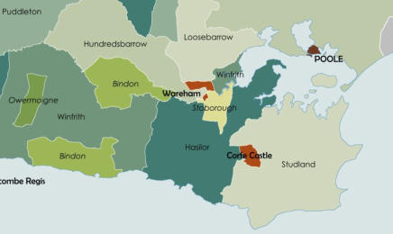
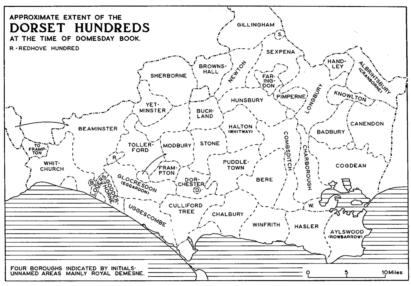
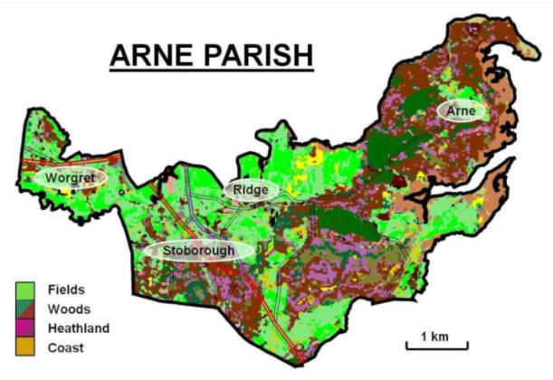
The Liberty of StoboroughStoborough Manor historically includes lakes, the river Frome, access to the Poole Harbour, viking ruins, views of Wareham Castle, Heaths, Meadows, Farms, Yacht Clubs, public picnic areas, and more. Stobourgh is in the Administrative Divsion of The Hasler Hundred or Hasilor Hundred which was a hundred territory in the county of Dorset, England, containing the following parishes: Arne, Church Knowle, East Holme, Kimmeridge, Steeple, Tyneham. The Church — principally monasteries — held nearly two fifths of the land in the county, and except for the grants to Norman abbeys and bishoprics this had been so before the Conquest. Land directly held by the King, either as royal demesne or estates ‘escheated’ for lack of heirs or misbehaviour, amounted to about one-sixth.Between the Anglo-Saxon period and the Local Government Act (1888), the county of Dorset was divided into hundreds and boroughs (and from the mediaeval period, liberties as well). The Local Government Act (1888) replaced the hundreds and liberties with urban and rural districts, based on the sanitary districts of the Poor Law Unions which existed in parallel with the hundreds/liberties from 1834.While numerous minor changes took place during that period, the general pattern remained stable. The subdivisions below within hundreds and liberties are the old civil parishes, into which the tithings (the original sub-divisions of the hundreds) came to be fitted. (Civil parish is used here in the sense of an "area for which a poor rate is or can be assessed", a unit which has thus been in existence de facto from the establishment of the Elizabethan Poor Law; the term itself dates from mid 19th century legislation such as the Poor Law Amendment Act 1866.)The following are the units existing immediately prior to the Act of 1834, with some additional changes noted up to the reforms of the Local Government Act 1894 and their immediate aftermath. Liberties and Boroughs are listed for completeness.Prior to the 1834 Act, the hundreds were grouped, mostly for taxation purposes, by divisions, which were rearranged by local Act of Parliament in 1830. See List of divisions in Dorset.Arne is a village and civil parish in Dorset, England, situated 4 miles (6.4 km) east of Wareham. The local travel links are located at Wareham railway station. Bournemouth International Airport is 11 miles (18 km) away. The main road through the village is Arne Road connecting Arne to Wareham. The village is situated on the Arne Peninsula, which protrudes into Poole Harbour opposite the town of Poole.Stoborough is close to the Sea and Beaches and Stoborough Manor has the Frome River on the other side of Wareham and part of the Harbor as its Norther and Northeastern borders. The the estuary of the River Frome extended to the Stoborough and has been called the gate of Purbeck. Until towards the close of the fourteenth century, it was a seaport town holding a position both politically and geographically similar to that of Southampton. Stoborough is a 5 minute drive to the southern beaches and ocean or you could boat from Stoborough River property into the ocean.References: https://en.wikipedia.org/wiki/List_of_hundreds_in_Dorset#Liberties
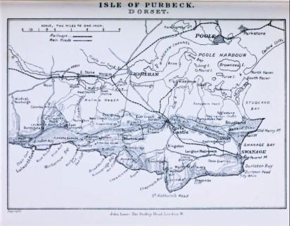
Stoborough Manor Lands are south of the East Wall and may historically include the Priory at the bottom middle of the map
Several local areas near Stoborough use the name "Stoborough," reflecting their
connection to the village. These include:
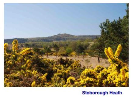
Stoborough Heath: A designated nature reserve and Site of Special Scientific
Interest (SSSI) located to the east of Stoborough. It's a heathland area known for its
wildlife and conservation value.
Stoborough Green: A residential area just north of Stoborough village, known for its
community feel and proximity to the surrounding countryside.
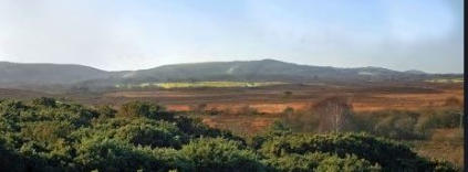
Stoborough Meadow: Part of the Stoborough Heath National Nature Reserve, this
area is a mix of wetlands and meadows that contribute to the rich biodiversity of the
Here are beautiful pictures of the Region of Stoborough . Isle of Purbeck in Dorsetshire. Escape the crowds and head to one of the most serene and beautiful regions of Southern England which was Ancient Wessex.